
AI reveals unseen human activity across the world’s oceans
Artificial intelligence can be used for unsavory things, like any technology. But researchers at the nonprofit Global Fishing Watch have revealed a promising use case — enlisting AI to accurately track human activity on the oceans, according to the group’s new study published in the journal Nature.
There’s a lot out there that has long floated under the radar of monitoring systems. The includes the so-called dark fleets involved in illegal and unregulated fishing.
Marketplace’s Lily Jamali spoke with David Kroodsma, director of research and innovation at Global Fishing Watch, about its work. AI, he said, can “point us towards the information we need to manage the ocean better.”
The following is an edited transcript of their conversation.
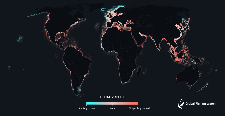
David Kroodsma: We produced the first-ever global maps of fishing activity about five years ago using transponders from vessels that broadcast their GPS positions. That was really exciting. However, there was a huge problem, which is we had no idea how many boats did not broadcast their positions. And we didn’t know how much we were missing. What we’ve done in this study is take satellite imagery and literally take pictures of the ocean at scale and count the boats. And what we found really surprised us. About three-quarters of large fishing boats were previously dark to our monitoring systems.
Lily Jamali: And artificial intelligence has helped you do some of that work. Can you explain how AI has augmented the research that you’re doing?
Kroodsma: So AI is what makes it possible to do these planetary studies. You imagine an analyst could sit and look at one of these pictures and label where there are boats and then match them up to GPS positions. But with AI, we can do this at scale. And we processed about 2 million gigabytes of satellite imagery. For scale, that would take about 2,000 laptops to fit all of that data on computers. And that allows us to show a comprehensive picture of human activity in the world ocean.
Jamali: And what surprised you as you’ve gotten to see what that activity looks like in great detail?
Kroodsma: Oh, there’s, there’s so many surprises looking at this data. The first is how much fishing activity was not previously monitored, especially in South and Southeast Asia. Another surprising thing, though, is you’re able to see all the offshore energy development. And what we saw in the last five years is that the number of wind turbines has outpaced the number of oil platforms in the ocean, which is a very exciting milestone. Another fascinating thing is that we saw fishing decline by 12% during the pandemic, and hasn’t recovered since.

Jamali: And do you have a sense of why that is?
Kroodsma: There’s lots of reasons. Some of it was decreased demand during the pandemic, another may be just a longer-term trend towards less fishing. We maxed out the number of fish we can catch in the ocean about 40 years ago. We’re catching the same amount of fish as we did in the 1980s, and so we can’t fish more. In fact, if we fish less, we might actually catch both the same amount of fish and make more profit for fishers. So fishing is likely to decline slightly. On the other hand, offshore oil, offshore wind, transport is all growing exponentially. And although fishing has historically been the way humans have had the largest footprint in the ocean, all the other types of industrial activity are catching up.
Jamali: What are you hoping that this kind of use of AI analysis will do?
Kroodsma: One thing, to be clear, is this type of AI analysis is not a substitute for governments sharing their data. Governments have all types of information about what fishing activity is happening, where there’s oil development, where wind development is happening, and that information is not necessarily public. And then sharing that information is extremely important. Artificial intelligence can fill in the gaps. It can tell us where we need to help build out those maps, it can tell us where human activity is happening. It provides us that global picture and points us towards the information we need to manage the ocean better. Every other breath you take is oxygen that was produced by the ocean. The ocean is half the life on the planet and provides a billion people with their primary source of food. And it’s being horribly managed. We need better information to manage this shared resource.
Jamali: How did you get so immersed in trying to provide that kind of resource for people?
Kroodsma: Personally, you know, I’m a researcher and I’m excited about discovery. And I got into this field because of the boom in satellite imagery and satellite data a little over a decade ago, I saw the potential. And honestly, the ocean was the most interesting space because it was the least discovered. It is the area where we still have new maps to be made. And it’s just exciting to make those maps for the first time.
You can check out Global Fishing Watch’s interactive maps here.
David Kroodsma said those maps reveal a “new industrial revolution” happening on the high seas.
Some of the illegal fishing that’s been identified is taking place in marine protected areas. Global Fishing Watch spotted five vessels a week, on average, around the Galápagos Islands and more than four times that at the Great Barrier Reef off the coast of Australia. These are among the best-monitored reserves in the world, according to The Guardian.
Kroodsma hopes this more accurate map that his team’s been building can help track greenhouse gas emissions at sea and marine degradation caused by oil pollution.
Also important to note, the largest cases of illegal fishing and “forced labor” occurred on vessels that did not use tracking devices.
Stories You Might Like


The future of this podcast starts with you.
Every day, the “Marketplace Tech” team demystifies the digital economy with stories that explore more than just Big Tech. We’re committed to covering topics that matter to you and the world around us, diving deep into how technology intersects with climate change, inequity, and disinformation.
As part of a nonprofit newsroom, we’re counting on listeners like you to keep this public service paywall-free and available to all.
Support “Marketplace Tech” in any amount today and become a partner in our mission.