NASA’s Jet Propulsion Laboratory develops imaging spectrometers to detect emissions of the potent greenhouse gas. Senior scientist Rob Green explains the role of the technology in the effort to mitigate climate change.
This year could become the hottest one ever recorded. In reporting on the climate crisis, carbon dioxide gets most of the headlines. But molecule for molecule, methane is a far more potent greenhouse gas. It’s odorless and colorless, making it difficult to detect.
“You could be standing within, you know, a few feet of a massive methane plume and not know it was there,” said Riley Duren, CEO of Carbon Mapper, a nonprofit organization that tracks greenhouse emissions.
While CO2 can linger in the atmosphere for centuries, methane lasts more like seven to 12 years. And because methane is so potent, the ability to quickly detect and fix leaks could have an immediate climate benefit.
Carbon Mapper carries out such detection by flying planes with imaging spectrometers over oil and natural gas hubs and other spots where leaks can cluster. But to scale things up, it’s working with NASA’s Jet Propulsion Laboratory on an instrument that can detect methane releases from space.
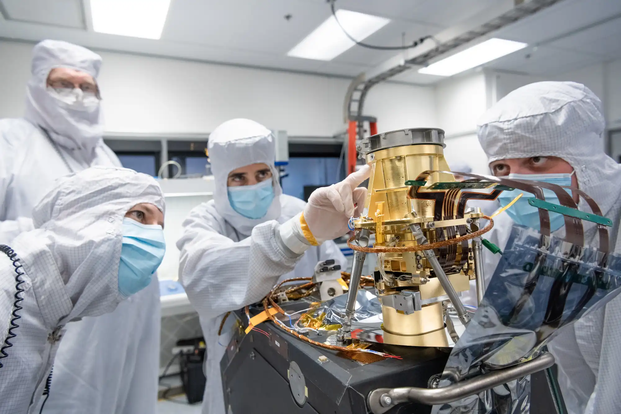
Marketplace’s Lily Jamali recently spoke about the mission and its mechanics with JPL senior research scientist Rob Green at the lab’s campus in Pasadena, California, outside the “clean room” where the instrument has been developed.
The following is an edited transcript of their conversation.

Rob Green: That is a vacuum chamber where we can open it, put an instrument in there and then pull it to a vacuum so it’s experiencing the environment of space. The other thing we have to do is take it to the temperatures that it would experience in space. So we want all the different elements to experience the same environment as if it was orbiting the Earth. So these are the first tests after it’s been sent through what we call Vibe, which is after we finished building it and characterize it, we send it up to a shaker table, and we vibrate it as if it was on a rocket going to space. And we check to make sure after the vibration that everything is where we expected it to be and it’s ready to go for the next phase, which will be delivery to the customer for integration with the spacecraft, then mounting on the rocket and then launching into Earth orbit, where it will begin to observe methane around our planet.
Lily Jamali: In this clean room that we’re looking at, there’s this giant, silver cylinder on its side, but the actual satellite that you’re going to be sending into space eventually, is it in there or next to it? It’s in there? And how big is that?
Green: Let me show you over here, we have a 3D solid model. This is the outer box of the instrument. There is a spacecraft that is not here. That will be attached. This is what’s inside that shell. This is where we take the white light that our eyes see and break it into the rainbow and in wavelengths our eyes don’t see out in the infrared, where we can see that spectral fingerprint of methane and map it wherever it’s occurring on the surface of the Earth. And that would be an indication that there’s a methane leak there that we want to understand and hopefully mitigate.
Jamali: So when we say you’re sending a satellite into space to monitor methane, at scale, this is the thing that’s doing it. It’s only about, you know, 2 feet high by 1 foot on the bottom. That’s the base?
Green: Yep, that is the instrument. The satellite will have a spacecraft, the spacecraft has solar panels, it needs energy in space, and it has attitude control— we have to make sure this instrument is pointing in the right direction. And it has communication, right? That spacecraft is incredibly important because it receives the signals from the Earth as to where to point. And then it sends the data back down to the ground so we can analyze it and see the methane signals.
Jamali: Why can’t we go in that room and see the real thing? Explain how sensitive this instrument is.
Green: So it turns out if you get dust in various places, particularly on optics, that can impact the quality of the measurement because we’re looking at light, counting photons. Also, if you get a little bit of dust or something in the electronics and that causes a short, right, a spark, that can end the mission. So we treat everything ever so carefully because you don’t get to bring a satellite back down and fix it except if you’re on the space station.
Jamali: How long did it take to conceive of this instrument that we’re looking at?

Green: That’s a really interesting question, and I could begin at the beginning. The first-ever imaging spectrometer was built at the Jet Propulsion Laboratory, called the airborne imaging spectrometer. It was conceived in 1979, and it first flew in 1982. And that’s what caused me in graduate school to come to JPL to work with this class of instrumentation. So it’s been a long road.
Jamali: Wow, you’ve been on the case for 40 years?
Green: Effectively 40 years, and I’ve had a track record of tens of imaging spectrometers. From Mars to the moon. There’s one going to Europa, and quite a few around Earth and quite a few airborne imaging spectrometers. My career has been built studying rainbows. It’s quite, quite remarkable. I’m quite pleased by that. So it feels wonderful, I’m incredibly gratified. We’ve used the spectrometers to answer important questions across the solar system. But here we’re taking it to our home planet to look at a really pressing question, [which] is where are the greenhouse gases coming from? And with that information, we can make decisions to mitigate the methane, being the most important right now to tackle.
Jamali: You took my tacky segue. I was gonna say, let’s bring this back to Earth because I want to understand how this does the thing that we need to be doing here. Methane is this incredibly potent greenhouse gas, more potent in the near term than carbon even, carbon dioxide. What is the idea that you can do what with this instrument exactly?
Green: So we can see methane emitters around the planet and identify them and report them. And then decision-makers can make decisions as to how to mitigate them. This is the spectral fingerprint of methane. For example, this actually is the methane plume that came from the Aliso Canyon blowout.
Jamali: This was back in 2015 in the community of Porter Ranch here in Southern California.
Green: Exactly. We had an airborne spectrometer flying at that time, and we mapped the plume while it was happening. And then after they claimed it was out, we mapped it again to make sure it was out and we were able to do that with imaging spectroscopy.
Jamali: Well, why does this work have to happen at JPL? This is one of the premier institutions, scientific institutions in our country. That says something, the fact that this work is happening here. Why can’t it be done, you know, in a private lab somewhere?
Green: Currently, the state-of-the-art imaging spectrometers are developed at JPL because we’ve been working on it for, again, decades, in particular because it’s useful to us for a whole set of NASA science questions. If you want to know what are the minerals on the surface of Mars or the habitability of the moon Europa of Jupiter? A spectrum is a powerful way to answer that question. So we’ve invested at JPL and at NASA in this technology to stay right at the forefront. So it’s a natural place to come for building the prototypes. Now, we are expecting copies of this instrument to be built in the private sector. So absolutely, the plan is to pass this on and then work on the next thing in terms of imaging spectrometers.
Carbon Mapper has a public data portal that you can use to see for yourself where methane superemitters are clustered based on the nonprofit’s airplane surveys.
You can also check out reports from two state agencies, one in California and the other in Pennsylvania, that show how regulators are using this kind of emissions data.
And finally, it’s hard not to nerd out just a little when you’re at JPL. On our visit, our team got to watch scientists hard at work on a satellite that will one day orbit Jupiter to study Europa. That’s one of the giant planet’s moons where scientists suspect there could be conditions suitable for life.
Side note: We loved seeing deer roaming the JPL campus.


